Keating Channel Pedestrian Bridge
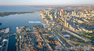
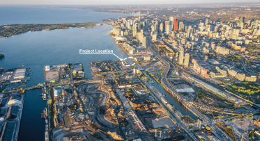
The Keating Channel pedestrian bridge will connect the central waterfront to Villiers Island and the expanded park system along the new mouth of the Don River.
The Keating Channel pedestrian bridge will connect the central waterfront and emerging neighbourhoods like Quayside with new housing and green space on Villiers Island. It will provide a vital connection for thousands of new residents and estimated millions of visitors to a growing network of waterfront destinations and an expanded regional park system along the Don River.
Beyond providing an elevated path of travel across the water, the bridge will also be a destination—offering places to stop, rest, gather, interact and enjoy the views.
This project is a partnership between Waterfront Toronto and the City of Toronto, in collaboration with Host Nation and Treaty Holder, the Mississaugas of the Credit First Nation (MCFN).
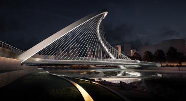
On May 06, 2024, following a design competition, the project partners announced the selection of WilkinsonEyre's, design concept, Equinox Bridge, as the chosen design for the Keating Channel pedestrian bridge. The Equinox Bridge is characterized by a signature S-shaped “arch bridge” with a suspended deck connected by a sculptural array of fanning cables.
Quick Facts
Background
The Keating Channel Precinct Plan (2010), the Villiers Island Precinct Plan (2017), and the Port Lands Planning Framework all imagined a pedestrian and cyclist bridge that crossed the Keating Channel, linking the Central Waterfront to Promontory Park and Villiers Island. These plans were all informed by extensive community consultation and engagement.
In May 2023 Waterfront Toronto and its partners issued a Request for Qualifications (RFQ) and Design Competition for a bridge that would create a distinctive gateway and accessible active transportation link from downtown to Villiers Island.
In keeping with the project partners’ commitment to public engagement, Waterfront Toronto established a Community Advisory Committee (CAC) to support the Design Competition stage of the project.
After a Design Competition that included a virtual public meeting and online survey that heard from over 2000 community members, the project partners announced the selection of WilkinsonEyre's design, Equinox Bridge, as the chosen design for the bridge.
The Equinox Bridge is characterized by a signature S-shaped “arch bridge” with a hung deck and sculptural array of fanning cables. The orientation of the bridge’s curves align with the summer solstice sunset and the winter solstice sunrise. The design team consists of recognized local and international firms, including WilkinsonEyre (design architect), Zeidler Architecture Inc. (local architect), Arup (engineer), Two Row Architect (Indigenous consultant), and PLANT Architect Inc. (landscape architect).
Project Goals
Together, Waterfront Toronto, the City of Toronto, MCFN and the CAC, identified and refined six project goals to guide the bridge design and implementation:
1. Create a Beautiful and Distinctive Gateway to the Waterfront
Becoming a landmark and a destination on the waterfront and complementing the existing Port Lands bridges.
2. Connect the City and Villiers Island
Connecting Quayside to an expanded regional park system along the Don River by providing safe, direct, and equitable access across the Keating Channel.
3. Incorporate a Living Landscape
Celebrating our connections with land and water by integrating nature in the design and offering opportunities for biodiversity.
4. Create with Indigenous Voice and Agency
Contributing to the visibility and overall wellbeing of First Nations, Inuit and Métis Peoples in Toronto through Place-making and Place-keeping and honouring Indigenous ways of knowing and being.
5. Embody Sustainable Strategies and Innovation
Symbolizing, representing, and celebrating sustainability, climate resiliency and green infrastructure, extending to cost efficiency, life-cycle analysis, constructability, durability, and maintainability, to the extent possible.
6. Create a Place for All People
Offering unique, inclusive experiences of transition, interaction, observation, comfort, discovery, sensation, safety, and access to all users.
Indigenous Design and Engagement
Incorporating Indigenous design principles and engagement with Indigenous communities is key to this project. Waterfront Toronto is working with the Mississaugas of the Credit First Nation, Host Nation and Treaty Holder, and the City of Toronto’s Indigenous Affairs Office to achieve this goal and support local Indigenous arts, cultures, storytelling, histories, and traditions. The effort focuses on celebrating Indigenous Place-making and Place-keeping – the collective re-imagining of public spaces to strengthen the connection between place, community, values, culture, past, present and future.
Further Indigenous design integration will be guided by the MCFN and informed by engagement and collaboration with Indigenous consultants, team members, organizations, and communities, throughout the course of the design phase.
Accessibility
The bridge will provide an accessible path of travel across the Keating Channel. It will go above and beyond AODA compliance and adhere to the City of Toronto’s Accessibility Design Guidelines [LINK] and Waterfront Toronto’s Accessibility Design Guidelines, Version 1 [PDF].
Active Transportation
The bridge will complement existing pedestrian and bicycle infrastructure, including the separated bike lanes on the Cherry Street bridge that connect the Martin Goodman Trail to the bike paths on Villiers Island and Toronto’s greater cycling network. This bridge will offer an additional crossing, connecting the Water’s Edge Promenade to the east of Parliament Slip to a future park and pedestrian pathways at Promontory Park North.
Design Competition
In May 2023, Waterfront Toronto and its partners issued a Request for Qualifications (RFQ) seeking architects, engineers, landscape architects and other design professionals to submit statements of qualifications to produce innovative design proposals for the bridge. Thirteen (13) submissions were received from a variety of local, national and international teams. Following careful evaluation of the submissions, five (5) Proponents were selected to participate in the Design Competition stage.
As part of the design competition, Waterfront Toronto heard from over 2,000 people through a virtual community consultation, including a virtual meeting on September 28, 2023 and an online survey that was open for one week from September 28-October 5.
Learn more about the virtual design presentations.
Read the public consultation summary report [PDF].
An evaluation committee made up of Waterfront Toronto, City of Toronto and Mississaugas of the Credit First Nation staff reviewed the designs considering input from technical advisors, a Community Advisory Committee, Indigenous communities and the public. After careful consideration of all the submissions from the shortlisted teams, the Equinox Bridge was selected.
Equinox Bridge addressed the project goals in a number of ways, including:
- Creating accessible spaces with a barrier-free connections at both landings
- Incorporating a living landscape through planting design, which uses pollinator species, rainwater filtration, and contributes to soil remediation and ecosystem management.
- Using sustainability strategies, including low carbon and local materials, green technologies, and integrated wind breaks.
- Integrating Indigenous design through a lighting design that showcases four (4) different star constellations that are significant to local Indigenous communities.
- Utilizing the “S” form as a traffic calming measure to accommodate various active transportation modes of travel.
- Providing places to pause with lowered seating areas so everyone can get closer to the water and enjoy the view.
The bridge is anticipated to be complete in 2026.
This project funded, in part, by the Government of Canada.

Related Documents
Connecting downtown to the Port Lands with an active transportation bridge
Tell Us What You Think of the Keating Channel Pedestrian Bridge Design Competition Proposals
Shortlisted Proponents for the Keating Channel Pedestrian Bridge