Largest Park in a Generation Opens on City of Toronto’s New Island through Transformative Port Lands Flood Protection Project

July 18, 2025, TORONTO – The Honourable Julie Dabrusin, Federal Minister of Environment and Climate Change and Member of Parliament for Toronto-Danforth, Jennifer McKelvie, Parliamentary Secretary to the Federal Minister of Housing and Infrastructure, Amarjot Sandhu, Parliamentary Assistant to the Ontario Minister of Infrastructure, Toronto Mayor Olivia Chow, and Councillor Paula Fletcher (Toronto-Danforth) today welcomed hundreds of visitors to Toronto’s newest island, Ookwemin Minising, to celebrate the opening of the island’s marquee attraction, Biidaasige Park. This event marked the beginning of a weekend filled with exploration and celebration as people of all ages are invited to experience the newly transformed Don River, and Biidaasige Park. Learn more about this park and the community activities on the City’s website: toronto.ca/BiidaasigePark.
This is a landmark achievement in the $1.4-billion tri-government investment in flood protection and waterfront revitalization, including more than $465 million by the Government of Canada, more than $471 million by the Government of Ontario and more than $471 million by the City of Toronto.
This island, renaturalized Don River and park add to the host of waterfront destinations made possible by 20 years of tri-government investment in Toronto’s waterfront renewal. They offer immersive and adventurous areas to explore, joining the already iconic red, yellow, and orange bridges that make the new island a must-see destination.
This brand-new island and future waterfront community will offer visitors from across the city, region, and world an unparalleled new way to experience Toronto’s waterfront.
Next Step: New Housing and Destinations
A $1.4-billion tri-government investment has enabled the flood protection and naturalization necessary to unlock the Port Lands for revitalization and development. By building a new, naturalized mouth for the Don River, this has unlocked vital space for future mixed-use neighbourhoods on Ookwemin Minising. As flood protection nears completion, the new island is ready to launch.
In January 2025, the Government of Canada, the Government of Ontario and the City of Toronto agreed to contribute an additional $975 million ($325 million each under the tri-government model), to accelerate the development of new housing and destinations on Ookwemin Minising and along the waterfront at Quayside.
At full buildout, it is estimated that Ookwemin Minising will be home to more than 15,000 residents, nearly 3,000 jobs, and an additional 15 acres of parkland to be developed in later phases. The island also offers new exciting places to explore and discover, all surrounded by water and verdant green space.
About the City of Toronto’s newest Park
Biidaasige Park (pronounced "bee-daw-sih-geh" and meaning "sunlight shining toward us" in Anishinaabemowin/Ojibwemowin) is a sweeping greenspace that lines the new mouth of the Don River. This is the largest park to open in Toronto in a generation and the first public space to open on Ookwemin Minising. The park was built as part of an innovative approach to flood protection. Through tri-government investment, Port Lands Flood Protection project protects 174 hectares of land in the Port Lands and eastern waterfront from flooding.
The park is opening in two phases. Approximately 50 acres/20 hectares of parkland opened today, with an additional 10 acres/4 hectares set to open in 2026, along with the first-in-Canada Lassonde Art Trail.
Visitors to Biidaasige Park will discover an array of features designed for all ages and interests. Highlights of the 2025 opening include picnic areas, a vibrant playground featuring larger-than-life animal sculptures representing Anishinaabe, Ongwehonwe, and Huron dodems, Toronto’s first ziplines, and a recreation waterplay feature, the Badlands Scramble. The park also boasts recreational trails and cycling paths, including step-downs to the river for fishing and birdwatching, slips for non-motorized boats, and the Don Greenway wetland for birdwatching. Two dog off-leash areas and a pebble landing area for watercraft further enhance the visitor experience.
Key Facts about Biidaasige Park:
- 50+ acres/20 hectares of park with an additional 10 acres/4 hectares opening in 2026
- Picnic areas, playground with ziplines, Badlands Scramble, two dog off-leash areas and a pebble landing to launch non-motorized personal watercraft
- 5,000+ trees, 77,000+ shrubs and two-million herbaceous plants
- Accessible trails and facilities
Key Facts about Ookwemin Minising:
- A new island where the Don River meets the lake, formed by a newly created river valley that incorporates flood protection features that blend into natural landscape
- Named Ookwemin Minising (pronounced “oh-kway-min min-nih-sing" —meaning "place of the black cherry trees”)
- 98 acres/39 hectares in size, future home to over 15,000 residents through at least 9,000 housing units and nearly 3,000 jobs
- Planned to be a new community advancing best-in-Canada sustainable development practices
Key Facts about the next phase of waterfront revitalization:
- Toronto’s Eastern Waterfront will ultimately be home to 100,000 people
- Next steps will accelerate the creation of over 14,000 new homes on public and private lands at Ookwemin Minising and Quayside, including affordable rental housing.
- Taken together, the development of Ookwemin Minising and Quayside is expected to create an estimated 100,000 skilled trades jobs and add $13.2 billion to the economy.
-30-
Quotes:
“Biidaasige Park is a prime example of what we can build when we work together. What we’ve created is more than a park, we’ve transformed the Toronto waterfront, ensured critical flood protection for residents, and built the foundation for future housing and public spaces for the community. Our government is proud to support projects that reshape our cities and build stronger communities for generations to come.”
— The Honourable Julie Dabrusin, Minister of Environment and Climate Change
“Biidaasige Park is an outcome of strong partnership across three levels of government– one that builds for the future, protects the environment, and builds strong communities. Our government is proud to support projects that reshape our cities and build spaces for future generations to come.”
— Jennifer McKelvie, Parliamentary Secretary to the Minister of Housing and Infrastructure.
“With the completion of Biidaasige Park, we’re marking an incredible milestone in our plan to speed up the development of a new mixed-use community that will unlock 14,000 new homes, support 100,000 skilled trades jobs and add $13.2 billion to the economy. Under the leadership of Premier Ford, our government is delivering on our more than $200 billion plan to protect Ontario by building the infrastructure our province needs to keep workers on the job, support the tourism sector and drive economic growth.”
— Kinga Surma, Ontario’s Minister of Infrastructure
“Today is a historic day for Torontonians with the opening of Biidaasige Park – the largest park in a generation and a beautiful space along the city’s Eastern Waterfront. It is part of the revitalization of Toronto’s waterfront at Ookwemin Minising creating a city within a city with 14,000 new homes. Thanks to our partnership with the federal and provincial governments and Indigenous partners, we have advanced $2.4 billion to support this new community and advance Indigenous placekeeping in Toronto. Today’s opening of a new park and river are a significant first milestone.”
— Mayor Olivia Chow
"Today, we celebrated the partial opening of Biidaasige Park in the Port Lands. Indigenous Elders, Knowledge Providers and language speakers gifted the city the name for the new park Biidaasige, which translates as "sunlight shining towards us." Honouring the relationship of land, water and sunlight, the name for the new park reflects the hope and possibility of reconciliation. I am very grateful to accept the Elders and Knowledge Circle’s gift of a new name and pleased our new waterfront park represents a big step on the long road to reconciliation."
— Councillor Paula Fletcher (Toronto-Danforth), Chair, Infrastructure and Environment Committee
“The opening of Biidaasige Park and the new Don River is a profound moment of renewal—not just for the land and water, but for the relationships that continue to grow here. We are proud to see Indigenous voices, teachings, and design woven into this landscape. This project honours the spirit of Biidaasige, ‘the one who brings the light,’ and reflects a shared commitment to restoring natural spaces while recognizing the deep, living connection Mississaugas of the Credit First Nation has to this territory.”
— Ogiima Kwe Chief Claire Sault, Mississaugas of the Credit First Nation
“The opening of Biidaasige Park showcases the profound success of two decades of tri-government partnership. This park is not just a new way to experience the waterfront, it's a vital piece of flood protection infrastructure that has unlocked more public access to water and space for new housing on a new island, Ookwemin Minising."
— George Zegarac, President and CEO of Waterfront Toronto.
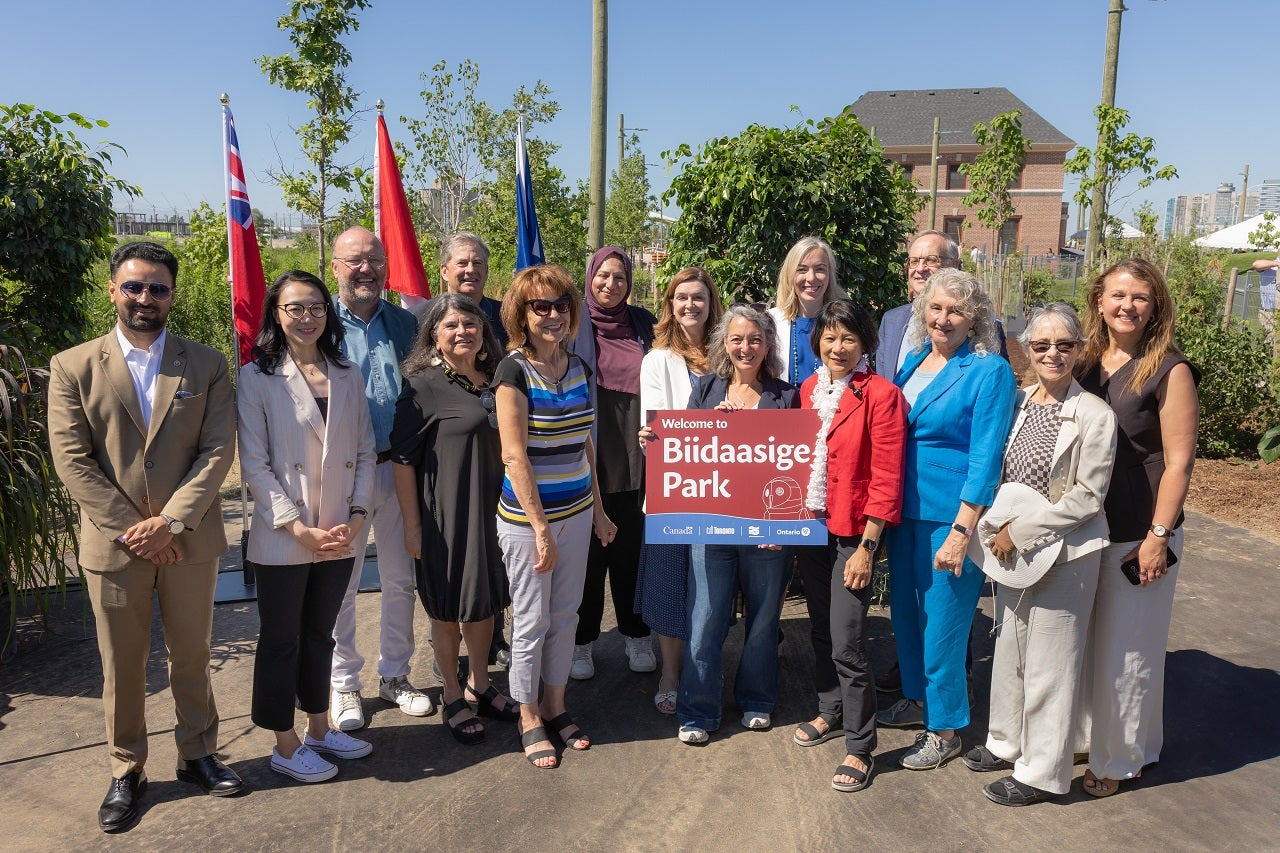
From left to right: Amarjot Sandhu, Parliamentary Assistant to the Ontario Minister of Infrastructure; Maggie Chi, Member of Parliament for Don Valley North; George Zegarac, President and CEO of Waterfront Toronto; Laura Solano, Partner at MVVA; Kevin Sullivan, Chair of Waterfront Toronto's Board of Directors; Ogiima Kwe Chief Claire Sault, Mississaugas of the Credit First Nation; Toronto Deputy Mayor Ausma Malik; Jennifer McKelvie, Parliamentary Secretary to the Federal Minister of Housing and Infrastructure; The Honourable Julie Dabrusin, Federal Minister of Environment and Climate Change and Member of Parliament for Toronto-Danforth; Leslie Church, Member of Parliament for Toronto-St.Paul’s; Toronto Mayor Olivia Chow; Rob Oliphant, Member of Parliament for Don Valley West; Councillor Paula Fletcher (Toronto-Danforth); Councillor Dianne Saxe (University-Rosedale); Julie Dzerowicz, Member of Parliament for Davenport.
Media Contacts:
Mira Shenker
Director, Communications and Public Engagement
Waterfront Toronto
media@waterfrontoronto.ca
Renée LeBlanc Proctor
Senior Communications Advisor and Press Secretary
Office of the Minister of Housing, Infrastructure and Communities
Renee.Proctor@infc.gc.ca
Ash Milton
Office of the Honourable Minister Surma
ash.milton@ontario.ca
Jas Baweja
Senior Communications Advisor, Media Relations & Issues Management
Strategic Public & Employee Communications
City of Toronto
Jas.Boweja@toronto.ca
Backgrounder: Biidaasige Park and New Don River Opening – Port Lands Flood Protection
July 2025
Overview
Opening the eastern section of Biidaasige Park (pronounced “bee-daw-sih-geh") and the new Don River is the most exciting milestone in the $1.4-billion project’s history. This milestone gives the public their first look at the new park system lining the new mouth of the Don River and opens the new river to visitors.
The new island, Ookwemin Minising (pronounced “oh-kwhe-min min-nih-sing"), that has been created through this ambitious engineering feat, totals 39.6 hectares. The longer-term vision for the island includes:
- Over 15,000 residents; over 9,000 housing units; nearly 3,000 jobs.
- Connecting the 60+ acres/24+ hectares of parkland delivered through Port Lands Flood Protection (PLFP), plus approximately 15 acres/6 hectares of additional parks still to be built on the island.
- Extending waterfront transit along Queens Quay East into the Port Lands.
- A complete community with an elementary school, community recreation centre, library, and child care centres, advancing best-in-Canada sustainable development practices.
About Biidaasige Park
- The park and greenspace in Biidaasige Park that is being delivered as part of the Port Lands Flood Protection Project is a total of 60+ acres.
- Approximately 50 acres/24+ hectares of the park (plus the new river) is opening in 2025, with the remainder set to open in 2026.
- Paddlers will be able to access the new river in summer 2025, with a few exceptions: paddling into the Keating Channel from the new river is not possible due to ongoing construction on Lake Shore Boulevard; the “canoe cove” area is not accessible due to ongoing construction on the western section of Biidaasige Park, set to open in summer 2026.
- Once fully open, the park is expected to attract over one million visitors annually.
- The new parks and greenspace include 5,000 trees, 77,000 shrubs, and two million herbaceous plants.
- The park will be managed and maintained by City of Toronto Parks and Recreation, in collaboration with other City divisions such as Urban Forestry and Economic Development and Culture, and agency and non-profit partners including the Toronto and Region Conservation Authority and Lassonde Art Trail.
The park includes a variety of amenities.
- Features opening in 2025 include:
- Picnic areas and barbeques.
- A playground that features larger-than-life animals and play structures, including: snowy owl stage, reaching raccoon play structure and Toronto’s first ziplines.
- A re-creation of the Cheltenham Badlands waterplay structure.
- Recreational trails and cycling paths, including a 5-kilometre loop around the river.
- The Don Greenway, a wetland ringed with a trail for bird watching, step downs to the river for fishing and a pebble landing where you can launch a non-motorized personal watercraft.
Two dog off-leash areas.
- Features opening in 2026 include:
- A historic Fire Hall with space for recreation programming.
- A ‘promontory’ or lookout over the new river and towards the city skyline.
- Canoe Cove, a pebble landing to launch small watercraft such as canoes and kayaks.
- An event lawn overlooking the harbour for larger-scale events.
Water’s edge promenade along the western edge of the island.
Other park details:
- The Lassonde Art Trail, a free immersive outdoor experience, will open in 2026 with a mixture of permanent and temporary public art installed throughout the park system.
- The park design includes Indigenous design features, which will be installed by 2026, including:
- Fire holder (Designed by Solomon King + Brook McIllroy).
- Teaching signifiers (Designed by Solomon King + Brook McIllroy).
- Directional Compasses / Marker Trees (Designed by Two Row Architect).
- Interpretive Signage (Designed by NVision Insight Group).
- Ceremony & Celebration Shade Structure (Designed by Tawaw Architecture Collective).
- Indigenous planting approach, including medicinal and edible plants.
- Dodem Animals (Designed by APE Richter / Christian Huba in consultation with MinoKamik & Mississaugas of the Credit First Nation): These are a series of carved wooden animals designed for play.
The trails and facilities have been designed to comply with the Accessibility for Ontarians with Disabilities Act (AODA) requirements as well as the Waterfront Accessibility Design Guidelines, building upon existing standards.
The Port Lands: History and Context
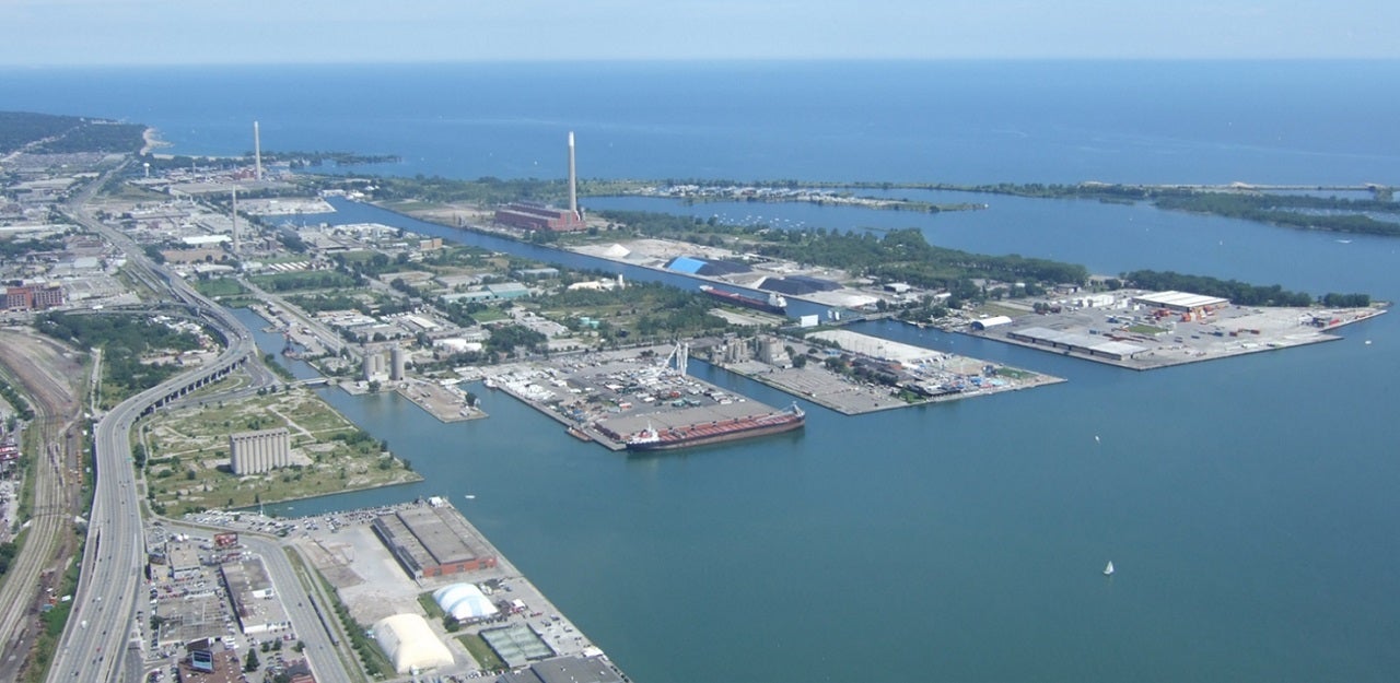
Looking southeast from downtown Toronto towards the Port Lands, prior to construction.
Bounded by the Keating Channel/Don River and Lake Shore Boulevard in the north, the Toronto Inner Harbour in the west, Ashbridges Bay in the east and Lake Ontario and Tommy Thompson Park in the south, the Port Lands was created by decades of infiling what was once once of the largest wetlands on Lake Ontario. Beginning in the late 1800s, the area was gradually filled in to make more land available for industry and shipping. As the natural marsh at the terminus of the Don River was filled in, the Keating Channel was created to provide an outlet for the Don River watershed into Lake Ontario and to convey storm water.
Port Lands Flood Protection
Although PLFP is one of the largest civil engineering projects currently underway in North America, what makes it unprecedented isn't the scale, it's the level of complexity: creating a naturalized river mouth that will provide flood protection up to and beyond a hurricane-sized event, overlying and adjacent to contaminated soils and groundwater, in the middle of existing urban lands, while enabling future community development. There are other flood protection projects around the world but none like this. And in Toronto, it's unlike anything attempted before.
Port Lands Flood Protection Project Breakdown
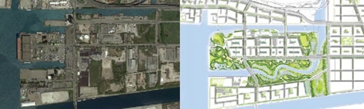
Left: An aerial view of the Port Lands before the start of construction. Right: Future vision of the Port Lands
Flood Protection
- Excavating the river valley and remediating contaminated soil.
- Creating the new grading around the river’s banks.
- Creating the wetlands and Don Greenway.
- Structures and features that allow for better conveyance and control of storm waters.
- The creation of four new bridges delivered as part of Port Lands Flood Protection.
- The development of roads, including realigning sections of Cherry Street as well as rebuilding a section of Commissioners Street and the Don Roadway.


