West Don Lands
The West Don Lands is an inclusive, complete community – people focused, family friendly, environmentally sustainable and beautifully designed for living.
Through thoughtful community engagement and collaboration with government partners, we created an award-winning master plan to transform 32 hectares (80 acres) of former industrial lands into a pedestrian-focused community built around parks, with housing for people of all ages, income levels and abilities, well-served by transit, retail and community amenities, and based on stringent sustainability requirements.
When complete, the West Don Lands will feature about 6,000 new residential units, 20 per cent of which will be affordable residences, ample employment and commercial space, at least one elementary school, and two child-care centres, all surrounded by nearly 9.3 hectares (23 acres) of parks and public spaces. Importantly, all developments must meet our Minimum Green Building Requirements and have achieved a LEED Gold certification, honouring our vision for green and sustainable communities.
Plans for the Area
The West Don Lands Precinct Plan is the overarching guideline for the development and servicing of the area. It defines the location, scale, character and function of all public spaces, streets, buildings and facilities to be provided and developed within the West Don Lands community. It was the result of the collaborative effort of many individuals and organizations over a two year period. Planning began in 2003 and was approved by Toronto City Council in May 2005.
How does the plan reflect our unique approach to revitalization?
-
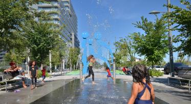
Leading with landscape—delivering the parks and public realm first. This serves as an additional enticement for developers when we take land out to market and helps ensure that valued greenspace is already in place for residents when development is complete. Inventive and high-quality parks and public realm are among the area’s hallmarks, each incorporating robust biodiversity and natural landscapes.
-
New waterfront neighbourhoods have a variety of housing types and amenities to ensure they meet the needs and reflect the diverse population of Toronto. In addition to condominiums, the West Don Lands includes affordable housing, student housing and a long-term care centre as well as a stunning new YMCA that serves the needs of everyone.
-
Providing affordable housing within a vibrant mixed-income community is an integral part of the development plan for the West Don Lands.
-
Enhancing connections and improving transit was a key feature of the plan for the West Don Lands. The new Cherry Street streetcar line runs within its own right-of-way between King Street and the rail corridor, making transit available within a five-minute walk from all West Don Lands homes and businesses. Future plans will see this line connected with the Waterfront East Light Rail Transit, which is currently in the early stages of planning.
-
In this digital age, connectivity is a crucial factor in attracting and retaining talent and enhancing and enriching the lives of residents. The West Don Lands will be among the most connected in the world. As part of Waterfront Toronto’s intelligent community initiative, the West Don Lands will have a global leading ultra-high-speed broadband community network.
Quick Facts
Boundaries: From Parliament Street to the Don River, King Street to the Rail corridor
Size:
- 32 hectares (80 acres)
-
6,000 new residential units
-
9.3 hectares (23 acres) of parks and public space
Sustainability: Stage 1 LEED ND GOLD certification under the pilot program established by the U.S. Green Building Council
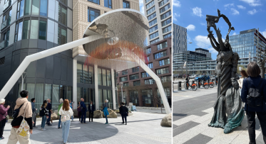
Public art: Mirage in Underpass Park; No Shoes in Corktown Common; Peeled Pavement on Mill Street; Untitled (Toronto Lamp Posts) on the Front Street Promenade; The Water Guardians on Front Street Promenade; Site Specific on Sumach Street; and Garden of Future Follies on Front Street Promenade.
Design teams:
-
Precinct Plan and Block Plans: Urban Design Associates and DTAH
-
Public Realm and Urban Design Teams: The Planning Partnership, PFS Studio and &Co.
-
Public Art Consultant: Jill Anholt
-
Heritage consultants: ERA Architects
Engaging the Community
For almost two years, community members, a variety of organizations, and government stakeholders were engaged and consulted. The West Don Lands Steering Committee and the Stakeholder Roundtable provided invaluable insight and shared community priorities.
The overall planning process was open, inclusive and transparent, and designed to result in a consensus-based final plan. An extensive collaborative public consultation process that included numerous public and stakeholder meetings and a week-long design charrette informed the development of the draft precinct plan. A sustainability audit was also complete to see how the sustainability aspects of the draft plan could be improved.
Environmental Assessments
The West Don Lands was subject to several environmental assessments (EA). The Lower Don River West Class Environmental Assessment was undertaken to examine alternative flood protection systems and their environmental effects, for the elimination of the flood risk along the Lower Don River. The study, in partnership with Toronto and Region Conservation, was conducted in accordance with the Conservation Authority Class EA for Remedial Flood and Erosion Control Projects and the Canadian Environmental Assessment Act.
Waterfront Toronto, in cooperation with the City of Toronto, also carried out a Class Environmental Assessment Master Plan Study concurrently with the precinct planning exercise. The purpose was to address water, sanitary servicing, stormwater management, and transportation needs, including transit.
Transit service in the West Don Lands was also subject to extensive environmental assessment planning and resulted in the innovative design for Cherry Street Transit.