Lower Yonge Update: The Details of a New Neighbourhood

We’ve held a third public meeting as we continue forming our plan to redevelop prime waterfront land between Yonge and Jarvis.
POSTED: SEPTEMBER 11, 2015 I DESIGN, PARKS AND PUBLIC SPACES
By Mira Shenker
If Queens Quay is the spine of the waterfront, then the Lower Yonge Precinct is its heart. The area between Yonge Street and Lower Jarvis connects the Central Waterfront with East Bayfront, currently under development. It’s also a central point between the Toronto Harbour to the south and the Financial District to the north. Getting this neighbourhood right is critical to waterfront revitalization.
A lot of work has already gone into the plans for how these 12 hectares should be redeveloped. The Lower Yonge Urban Design Guidelines and Lower Yonge Transportation Master Plan Environmental Assessment were presented to City Council in August 2014. These two plans now form the basis of a Precinct Plan that will guide this area’s redevelopment, ensuring this area gets all the infrastructure, public spaces, amenities and building types it needs to become a complete, sustainable neighborhood.
About 150 people participated in the third public meeting for the Waterfront Toronto and City of Toronto Lower Yonge Precinct Planning project this June. The purpose of the meeting was to seek feedback on the developing Precinct Plan as well as Pinnacle’s Development Application for the Toronto Star lands at 1-7 Yonge Street.
Christopher Glaisek, Waterfront Toronto’s VP of development and design, opened the meeting with a project update. Willie Macrae, senior planner with the City of Toronto’s Community Planning department, gave an overview presentation, followed by an update on the development application for 1 Yonge by David Pontarini of Hariri Pontarini Architects. See the City’s full presentation here.
The overview presentation included a handful of new elements introduced since the last public consultations were held in 2013. Waterfront Toronto and the City of Toronto have built on the Urban Design Guidelines and Transportation Master Plan, delving further into what this neighbourhood will need, from basic water, stormwater and wastewater infrastructure to community amenities. We also completed heritage impact studies and plotted timelines for delivering the parkland and road network. For an overview of the process to date and what’s changed since our last public consultation read here.
The full summary of our recent public consultation is available here. Here are a few elements of the plan that people were most interested in discussing at our June consultation:
The Park

“Lower Yonge Park,” as it’s currently being called, will occupy 1 hectare (2.4 acres) of land south of the newly extended Harbour between Cooper and Freeland – that’s roughly the size of two football fields.
There were two park options considered for green space in this neighbourhood: one large park or two smaller parks. Based on consultation feedback, there’s a strong desire for big open green space in this area. The proposed Precinct Plan now includes one central park.
Cycling and Walking Routes

More route choices for pedestrians will help create a walkable neighbourhood. The park seen here is the proposed Lower Yonge Park.
Changes to the development blocks will give pedestrians shortcuts. For instance, someone heading to Lower Yonge Park from Lakeshore and Yonge Street can cut through diagonally, landing at the corner of Harbour Street and Freeland Street. These mid-block connections are plotted based on “desire lines,” the direct routes people will want to take.

Potential cycling connections for Lower Yonge include an eastbound off-street lane along Lakeshore Boulevard.
New cycling connections are proposed along key routes. For context, it may be useful to keep in mind that Harbour would now be two-way between Yonge and Lower Jarvis. In this proposed plan, a bi-directional bike lane would run off street along the north-side sidewalk of Lakeshore Boulevard from Cherry to Bay Street. Separated, bi-directional lanes would run along the south side of the street on Harbour from York to Bay, and possibly as far as Yonge. Sharrows – pavement markings directing drivers and cyclists to share the lane – are proposed for Harbour between Yonge and Lower Jarvis Street, where space is limited. Cyclists can also travel east or west along the entire length of this area and beyond using the off-street bi-directional Martin Goodman Trail on Queens Quay. The painted on-street bike lanes that currently run along Yonge between Queens Quay and Front Street may be replaced by a separated on-street lane.
While participants at June’s consultation liked the general cycling plan for the precinct, several had concerns about the use of sharrows on Harbour, asking instead for a separated lane. Many also called for the City to create a north-south dedicated cycling connection. For instance, the cyclists travelling north on Yonge lose their designated lane when they reach Front. These connections are still just proposed, and will be studied and designed during the next phases of the Lower Yonge Transportation Environmental Assessment.
Tall Buildings

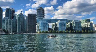
The new buildings proposed as part of Lower Yonge Precinct are shown here relative to other buildings in the skyline.
Building heights were the subject of some debate at this June’s consultation. While some participants worried that more height brings higher densities that will overwhelm the area, others felt that a few taller buildings is preferable to many smaller buildings.
The City of Toronto and Waterfront Toronto proposed building heights for this precinct based on studies that account for pedestrian level views, shadow impacts and the existing and future skyline. This team will provide recommendations for building heights based on the existing and planned building heights in nearby areas like the Financial District, the emerging South Core area, the St. Lawrence neighbourhood, and East Bayfront. The team will also consider the range of infrastructure and amenities that will need to be provided as part of each development.
Pinnacle’s proposal is the first of three development applications for the Lower Yonge Precinct and is being considered in the context of our on the Lower Yonge Precinct Plan. The tower height for 1 Yonge is still under review by City and Waterfront Toronto, and Pinnacle has also appealed their application to the Ontario Municipal Board. Find the existing and revised plans for the Pinnacle application on the City’s website here.
Next Steps
The plans outlined above are the result of the first two phases of the Lower Yonge Transportation Master Plan Environmental Assessment.. The next steps in this process involve a Municipal Class Environmental Assessment. This study sets the alignment and design of streets in the area. The transportation modelling we did as part of the Transportation Master Plan Environmental Assessment will also be further analyzed as part of this process.
We’ll ask for public feedback on the Municipal Class Environmental Assessment before it’s submitted to Toronto and East York Community Council for approval. This study, along with the others we’ve completed, will help assemble the final Precinct Plan for Lower Yonge. Before we finalize that plan and present it to Council, we’ll hold a public consultation and consider all the feedback we receive.
Stay tuned. Sign up here to receive updates on this project, including notices about upcoming public meetings.
Do you have more questions about this project? Email us at info@waterfrontoronto.ca or tweet us at @WaterfrontTO.
Sustainable Skyline: How Mass Timber is Shaping Toronto’s waterfront
Kiss n’ Sail Pilot Project Beginning Summer 2024 Announced