Waterfront Toronto’s Design Review Panel Reviews Villiers Island Density and Massing Study

PUBLISHED: MAY 2, 2024
BY: CHRIS GLAISEK, CHIEF PLANNING & DESIGN OFFICER
Amendments to the 2017 Villiers Island Precinct Plan, along with Official Plan and zoning by-law amendments, will be going before Toronto City Council this June to allow the City to maximize the amount of housing on this new island community. Significant investment in affordable housing, public realm, transit, community and servicing infrastructure will be required by the federal, provincial governments and the City of Toronto, as well as private developers, to make the vision of a complete, sustainable community a reality. How much investment required is, in part, tied to the number of people who will live and work on the island. So, determining density now is a critical step in the evolution of the project.
Over the past two years, the City of Toronto, CreateTO and Waterfront Toronto have studied options to increase density and a comprehensive presentation [PDF] was delivered to the Waterfront Toronto Design Review Panel (DRP) at its April 24, 2024 meeting. The analysis included multiple approaches to adding density to the island, and looked at the benefits and impacts of each one.
Futureproofing Villiers Island
Recognizing that Villiers Island is in its earliest stages with a 25+ year planning and implementation horizon to full completion, the study adopted a flexible approach to allow for future modifications as societal needs change. As such DRP saw an articulation of built form goals for the island to allow for the evolution of the City's priorities, policies and guidelines.
Density
While the plan presented to the DRP maintains the major guiding principles of a 2017 Villiers Island Precinct Plan [PDF], it also responds to a critical need to increase housing supply in downtown Toronto by increasing density by 60% over the 2017 precinct plan to accommodate a target of providing 30% affordable housing on public lands, and in total approximately 9,000 housing units for more than 15,000 new residents, and 3,000 jobs. By way of comparison, this density will be roughly a third larger than the originally approved housing units in the West Don Lands precinct.
To accomplish this, increased tower heights will transition down from the height peak at New Cherry Street gently to the west and south and more dramatically to the east. The lower heights in the east avoid shadowing sensitive new habitat of the new Don River valley created through Port Lands Flood Protection (PLFP), and limit shadows on the parks in order to allow plant material to survive and thrive as well as support a variety of recreational activity throughout the year, as illustrated below.

Getting to, and around, Villiers Island
While Villiers Island will largely be reclaimed as a habitat for humans and wildlife, it will continue to play an important role in servicing the Port of Toronto. In 2023, the Port of Toronto moved approximately 2.3 million metric tonnes of cargo and welcomed 45 cruise ships.
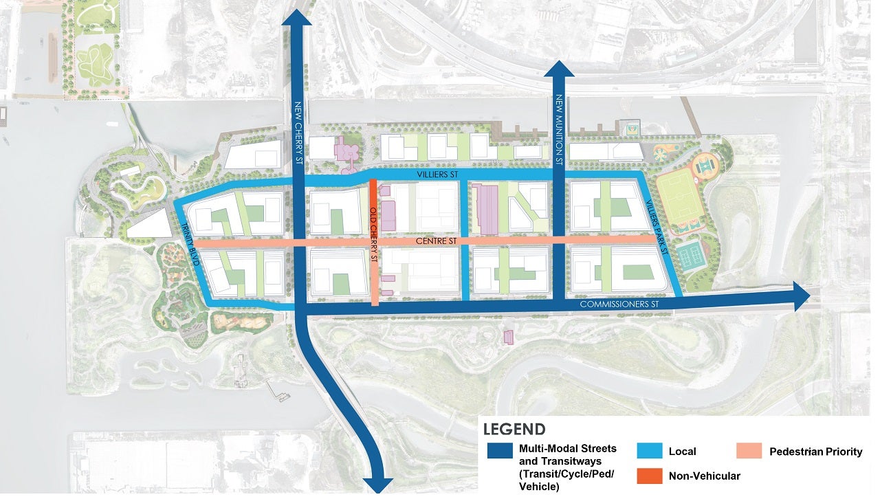
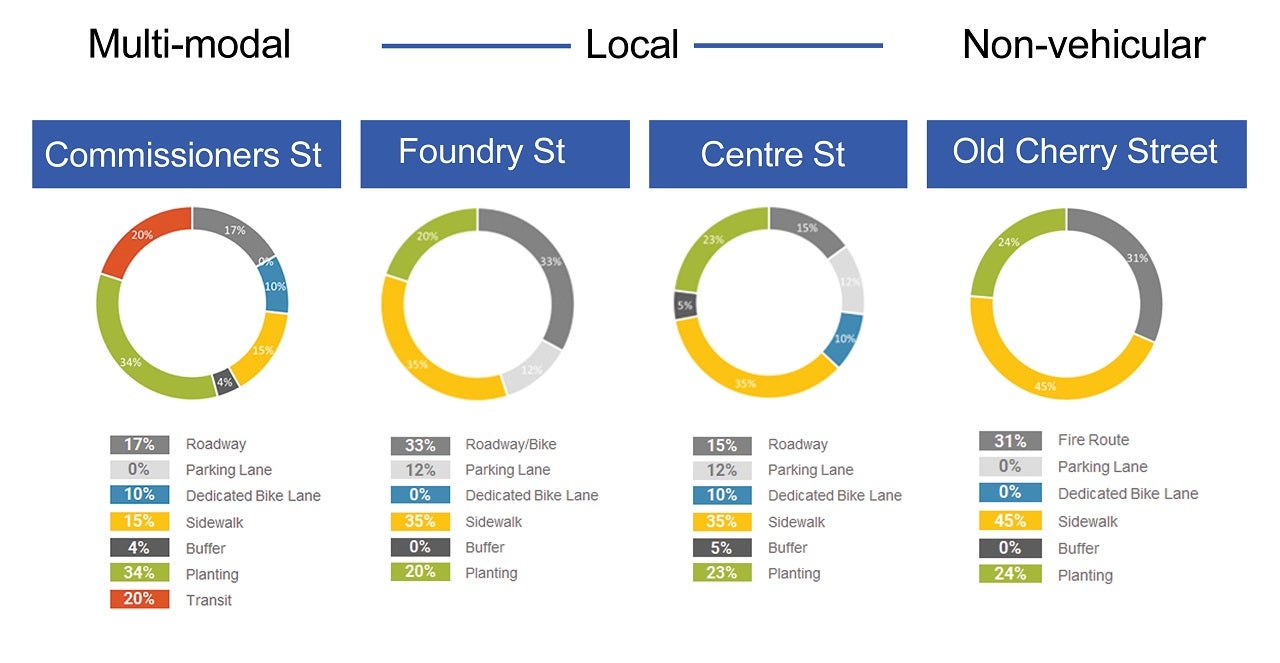
While all modes of traffic need to be accommodated, space in the right of way for pedestrians, cyclists and transit users has been prioritized as illustrated below. Streets already built through PLFP have been designed with low-impact development approaches and green infrastructure, which will give greenspace and trees space to thrive and allow a more natural, less manicured landscape to develop in the rights of way. This design means extra space was needed for the green landscaped portions of the rights of way.
What’s next
Following discussion, questions and consideration, the DRP voted Conditional Support for the proposed plan. A Conditional Support vote indicates that the plan, as presented, meets many but not all design excellence objectives. Since the DRP’s inception in 2005, a number of waterfront projects have received conditional support at early review stages and have been successfully implemented. As DRP Chair Paul Bedford reflected, “those projects whose proponents address and respond to the concerns raised by our Panel, such as Sherbourne Common and Underpass Park, have gone on to receive Full Support and have been successfully delivered.”
In summarizing the comments of the panelists, Paul Bedford affirmed that the study meets the density test of the panel, but summarized the panel’s feedback for the team:
- This has to be a 21st century neighborhood from A-Z, thinking completely in terms of built form, public realm, pedestrian amenities, community facilities -- everything.
- A fine-grained network is needed to let people move easily through the development blocks. He cited Toronto neighbourhoods Yorkville and St. Lawrence as places where through connections allow people to move freely outside the more structured street grid. To ensure this is accomplished on Villiers Island, the DRP asked to see greater detail of the mid-block connections and for those networks to be codified through zoning or some other policy mechanism.
- To ensure future design work for the public realm, including streets and mid-block connections, isn’t limited and can achieve that 21st-century design standard, the panel asked for more flexibility and simplicity in the zoning envelopes
- Design future streets so that they could be easily pedestrianized
Overall, the panel agreed that it is hard to look at just the massing and zoning without talking about the entire community holistically. So, the panel is looking for a better understanding on how this zoning will leave flexibility to design a public realm that prioritizes landscape, people/movement and breaks up what some felt are too-large development blocks.
Waterfront Toronto’s mandate is to ensure revitalization of the waterfront meets enhanced standards of design excellence, quality of place, sustainability and public accessibility. The DRP plays a critical role in helping shape projects to achieve excellence in buildings, parks, and public realm by providing advice to ensure the projects meet or exceed Waterfront Toronto standards for design excellence. Led by some of Canada’s most creative and accomplished city-building professionals, the DRP helps ensure we are building one of the world’s greatest urban waterfronts.
More information on the Design Review Panel and its process can be found in The Handbook [PDF] available on Waterfront Toronto’s website.