Flood Protection Milestone Puts New Waterfront City Within Reach

November 8, 2024, TORONTO - Today, the three orders of government, through Waterfront Toronto, reached a major milestone in a promise made to protect Toronto residents and businesses from the damages from severe flooding by completing a new mouth for the Don River and a new island.
Governments committed a combined investment of approximately $1.4-billion for a transformational waterfront revitalization project that protects existing Toronto neighbourhoods from extreme flooding and contributes to unlocking up to 240 hectares of land to build urgently needed housing and to construct the city’s largest park network in a generation. This historic achievement marks a big step in an eight-year major construction project to bring the vision for a waterfront city within a city to life.
“Today’s achievement demonstrates what can be accomplished when all orders of government work together to address major infrastructure challenges facing cities across the world” said Jack Winberg, board chair of Waterfront Toronto. “Undertaking a transformation of unprecedented scale requires unrelenting energy, focus and imagination sustained over a long period of time, which Waterfront Toronto has done for over 20 years.”
“Waterfront Toronto recognizes the value of doing the job right, and it shows. We set the bar higher for design innovation, sustainability and meaningful public engagement and have always met the challenge,” said Waterfront Toronto President and CEO George Zegarac. “This historic achievement unlocks much needed public land on Toronto’s waterfront. Our collective vision will lead us to complete a waterfront city that will ultimately become a home to over 100,000 people and a destination for 97,000 jobs. It starts on this brand-new island. Next year, we will open the largest park Toronto has opened in a generation.”
Just the facts:
The new island totals 39.6 hectares and is one of the last undeveloped areas of land just steps from Toronto’s downtown. This foundation for an inspiring vision of best-in-Canada city building includes:
- 20.2 hectares of new greenspace and parkland
- 19.4 hectares of developable land
- 6.1km of land for trails
- 4. 5km of underground utilities
- 2km of roads and 4 bridges with dedicated space for modes of active transportation
- The only naturalized shoreline in the Inner Harbour
An Indigenous Advisory Circle has chosen “Ookwemin Minising” (pronounced Oh-kway-min Min-nih-sing) as the island’s name meaning “place of the black cherry trees” in Anishinaabemowin/Ojibwemowin. Toronto City Council will consider the name November 13, 2024.
The longer-term vision for the island:
- Over 15,000 residents; over 9,000 housing units, nearly 3,000 jobs
- 20 hectares of parkland as part of a comprehensive 35-hectare park system
- Extending waterfront transit along Queens Quay East into the Port Lands
- A complete community – new island community advancing best-in-Canada sustainable development practices
Quotes
“Today’s milestone marks a significant step toward revitalizing the Toronto waterfront. Through collaboration with all orders of government, we’re protecting the Port Lands area from flooding, while building a more resilient city, and creating better access to the water, and allowing for future development, including much-needed housing.”
- The Honourable Ahmed Hussen, Minister of International Development of Canada on behalf of the Honourable Sean Fraser, Minister of Housing, Infrastructure and Communities
“The opening of the new mouth for the Don River is a major step in protecting residents in Riverside, Leslieville and the surrounding communities from the risk of flooding due to climate change. This advancement paves the way for our government’s ongoing efforts to revitalize and transform Toronto’s Port Lands.”
- Julie Dabrusin, Parliamentary Secretary to the Minister of Natural Resources and Parliamentary Secretary to the Minister of Environment and Climate Change and Member of Parliament for Toronto-Danforth
“Today’s north plug removal marks the completion of the new Don River, another milestone in the Port Lands Flood Protection Project. Once complete, these former industrial lands will be transformed into vibrant, mixed-use communities with housing, parks, retail spaces and more, demonstrating the success of our government’s historic capital plan of more than $191 billion to expand and renew critical public infrastructure over the next decade.”
- Amarjot Sandhu, Parliamentary Assistant to Ontario’s Minister of Infrastructure
“In 2017, all three orders of government recommitted to waterfront revitalization through equal investments in funding for Port Lands Flood Protection. This investment helps to unlock 240 hectares of public land that is a 10-minute walk from downtown Toronto. In 2025, we will begin to open the largest park system in Toronto that has opened in a generation on and around the new island. This is a significant step towards creating a waterfront city within a city on the Eastern Waterfront.”
- Mayor Olivia Chow, City of Toronto
“The long awaited dream is now a reality thanks to the exceptional work of Waterfront Toronto with the commitment and funding of the three levels of government. The Don River is free to run directly into the Harbour and the new Island - Ookwemin Minising – has been fully created. In a few years new generations of Torontonians will make their home on our beautiful Waterfront. It is a milestone moment for our city.”
- Paula Fletcher, Toronto City Councillor Ward 14 (Toronto-Danforth)
Media Kit:
Images and video can be downloaded on Google Drive
Backgrounder: North Plug Removal – Port Lands Flood Protection
Media Contact:
media@waterfrontoronto.ca
Backgrounder: North Plug Removal – Port Lands Flood Protection
November 2024
Removing the “north plug” is the most significant flood protection milestone in the $1.4B project’s history. This milestone completes the new mouth of the Don River, allowing the river to flow freely, and demonstrates the success of tri-government collaboration over 20 years to deliver a complex project through innovative city-building efforts. It marks the creation of a new island on Toronto’s waterfront and brings the vision of a waterfront city within reach. Across the Eastern Waterfront, plans include homes for more than 100,000 people and over 97,000 jobs along the Eastern Waterfront.
The new island that has been created through this ambitious engineering feat totals 39.6 hectares. The longer-term vision for the island includes:
- Over 15,000 residents; over 9,000 housing units; nearly 3,000 jobs
- 20.2 hectares of parkland as part of a comprehensive 35-hectare park system
- 19.4 hectares of developable land
- Extending waterfront transit along Queens Quay East into the Port Lands
- A complete community – new island community advancing best-in-Canada sustainable development practices
About the North Plug
The entire river valley is surrounded by cutoff walls – underground and underwater walls that contain the new river system. In the locations where water needs to flow, these walls were reinforced so they could function like dams once excavation was complete and the river was flooded. These reinforced sections are known as “plugs” because they were separating the new river from the surrounding water bodies.
In January 2024, the new river was filled with water, but the plugs remained to allow for a slow and controlled process. Once the water in the river was at the same level as the lake water, the plugs that separate the river from the lake could be removed.
The first to be removed was the “west plug” at the location where the new river meets Lake Ontario, in July 2024. Now, the north plug is being removed, which will finally reconnect the existing Don River with the new river valley we built, allowing the river to flow.
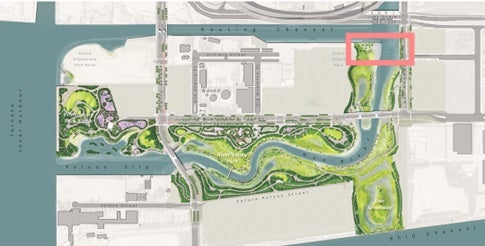
- The north plug is the portion of the wall that separates the existing Don River and Keating Channel from the new river valley through the Port Lands. It is south of the Lake Shore Bridge.
- To remove the plug, first the concrete will be ground off of the reinforcing steel beams. Once the concrete has been ground away, divers will cut through the beams so that they can be pulled out by an excavator.
- Until now, the North Plug has largely prevented the Don River from flowing through the new river valley. With its removal, the river can now flow freely. This is a major milestone towards achieving flood protection.
The Location

The “north plug” is south of the Lake Shore Bridge, where the Don River will flow into the new river valley – its location is identified on this map.
The Port Lands: History and Context

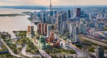
Looking southeast from downtown Toronto towards the Port Lands.
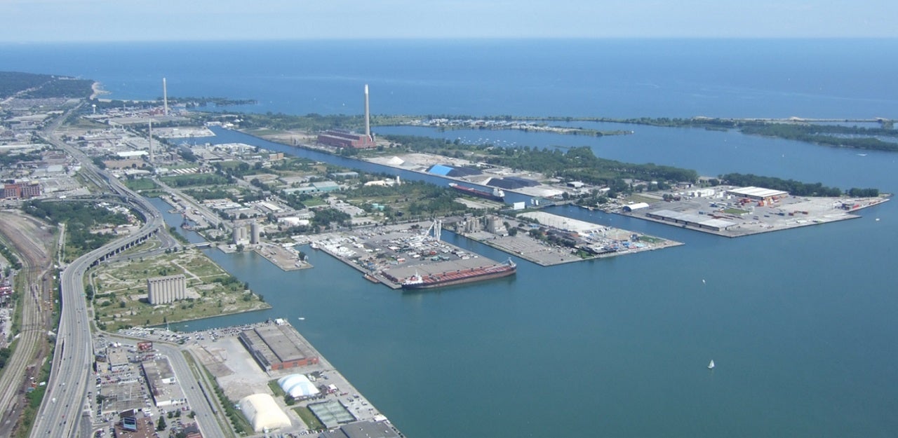
Bounded by the Keating Channel/Don River and Lake Shore Boulevard in the north, the Toronto Inner Harbour in the west, Ashbridges Bay in the east and Lake Ontario and Tommy Thompson Park in the south, the Port Lands was created by decades of infilling what was once one of the largest wetlands on Lake Ontario. Beginning in the late 1800s, the area was gradually filled in to make more land available for industry and shipping. As the natural mouth of the Don River was filled in, the Keating Channel was created to provide an outlet for the Don River watershed into Lake Ontario and a means to convey storm water.
Today, the Port Lands area sits within a designated floodplain, which is an area anticipated to experience flooding in the event of a regional storm or the 100-year flood – whichever is greater. Providing flood protection for the Port Lands was identified as a top priority by all three orders of government when they first established Waterfront Toronto in 2001.
In the last decade, governments across the country have had to contend with weather events that are occurring with more frequency and severity. In particular, floods are happening more often in urban areas and the financial risk to governments to pay for the damages is also increasing.
About Port Lands Flood Protection
Currently, about 290 hectares (715 acres) of southeastern downtown Toronto, including parts of the Port Lands, South Riverdale, Leslieville, south of Eastern Avenue and the East Harbour development site, are at risk of flooding from the Don River watershed and cannot be revitalized until they are flood protected. Port Lands Flood Protection is a comprehensive solution to flood protection that also addresses the fundamental challenge of transforming the underused and postindustrial Port Lands into a long-term asset that will support Toronto’s growth and economic competitiveness.
The project will create a new Don River in the middle of the Port Lands between the Ship Channel and the Keating Channel, as well as the foundations of a new urban island neighbourhood and more waterfront access for everyone. An Indigenous Advisory Circle has chosen “Ookwemin Minising” (pronounced Oh-kway-min Min-nih-sing) as the island’s name meaning “place of the black cherry trees” in Anishinaabemowin/Ojibwemowin. Toronto City Council will consider the name next week. It will also create new natural habitats and re-establish wetlands in the area, which provide social and environmental benefits and naturally moderate the effects of flooding and erosion. Naturalizing the mouth of the Don River will provide the necessary flood protection and unlock the development potential of this premier waterfront area.
Project Breakdown

Left: An aerial view of the Port Lands before the start of construction. Right: Future vision of the Port Lands once Port Lands Flood Protection is complete. The island will emerge as a connected and complete community with parks and opens spaces along the Don River, the Keating Channel and Lake Ontario.
The project's separate components can be divided among four broad categories:
Flood Protection
This includes:
- Excavating the river valley and remediating contaminated soil
- Creating the new grading around the river’s banks
- Creating the wetlands and Don Greenway
- Structures and features that allow for better conveyance and control of storm waters
Bridges
This includes:
- New Cherry Street Bridges replace the existing bridge over the Keating Channel and accommodate the future extension of transit into the Port Lands
- Cherry Street South Bridge spans the new river valley north of the Ship Channel
- Commissioners Street Bridge spans the new river valley west of Don Roadway
- Existing Lake Shore Bridge lengthened to accommodate widening of the Don River
Roads and other municipal infrastructure
This includes:
- Stormwater and wastewater systems
- Realigning a section of Cherry Street
- Rebuilding a section of Commissioners Street
- Rebuilding a section of the Don Roadway
Parks
Includes:
- Parks along the new river valley
- Park along the edge of Toronto Harbour
- Pedestrian and bike trails and paths, and waterfront access through new naturalized areas
Find a project breakdown with details about each component on the project website at https://portlandsto.ca/interactiveproject-map


