Take yourself on a tour of the Port Lands

POSTED: APRIL 29, 2024
In This Blog:
-
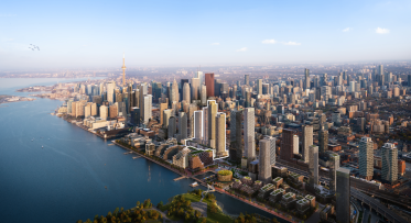
The Port Lands Flood Protection (PLFP) project is one of the largest urban renaturalization projects in Canadian history. While much of the work to date has been hidden behind hoarding, piles of soil and big machines, the new roads in the Port Lands now make it possible to get a better view of the progress we have made.
Map of route: https://maps.app.goo.gl/rNvnsjeAeoeDcHjA9
Background info:
-
Read a history of the Port Lands here [link to history page: History Of The Port Lands - Waterfront Toronto (portlandsto.ca)].
-
What happens after flood protection? Read about our plans for the new community that will be built on Villiers Island [link to blog about VI: Raising the Bar on Sustainability - Waterfront Toronto (portlandsto.ca)]
How to get there
This tour is designed for you to follow along while walking, rolling or biking. You can get to the Port Lands by…
-
72 Bus, get off at New Cherry Street and Lake Shore Boulevard East
-
504A Streetcar, get off at the Distillery Loop, and walk south on Cherry Street
-
Biking along the Martin Goodman Trail. Toronto Bike Share has a dock at New Cherry Street south of Lake Shore Boulevard.
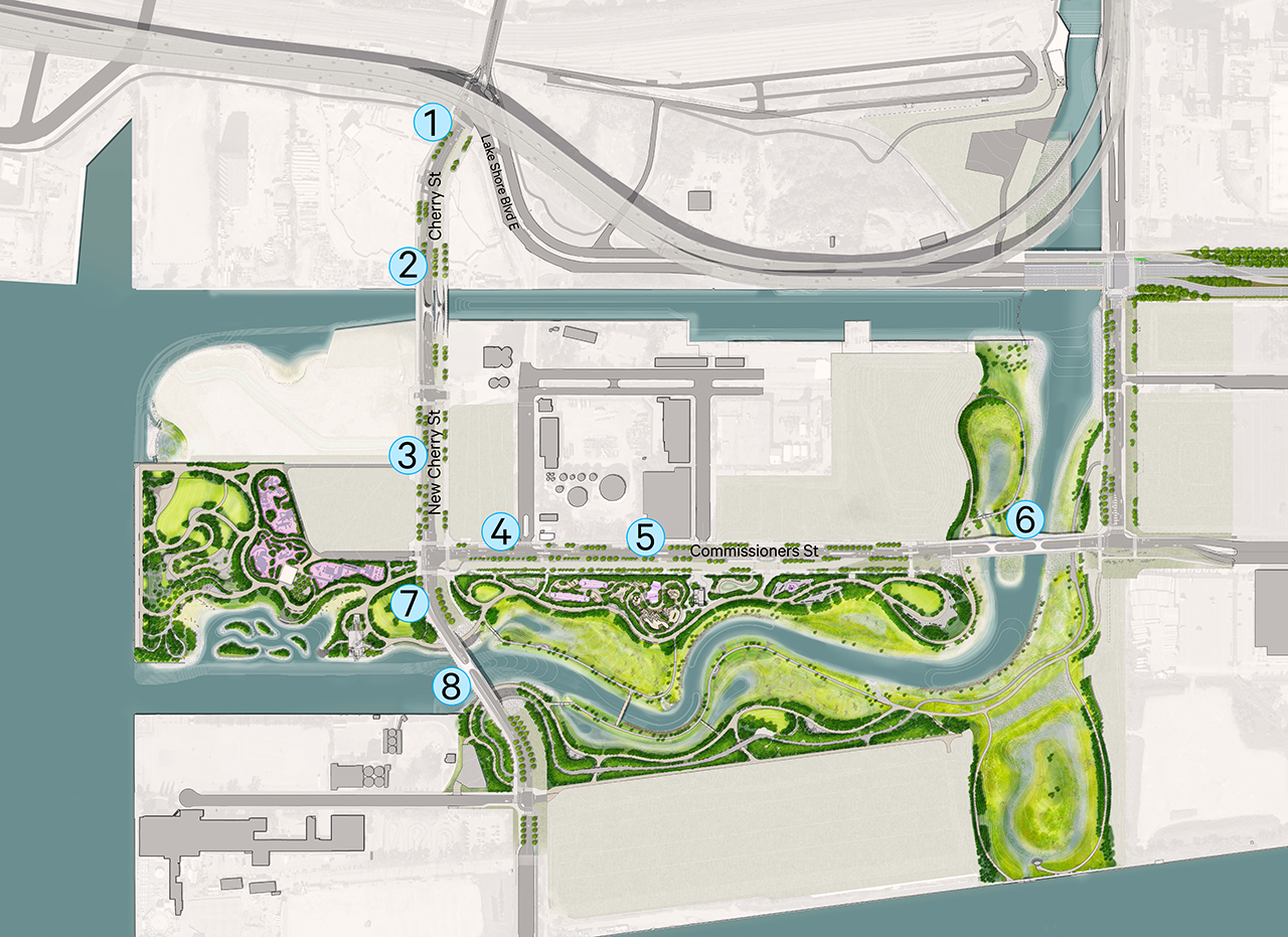
Where to start: Stop 1, Cherry Street and Lake Shore Boulevard
Begin your tour at the intersection of Cherry Street and Lake Shore Boulevard, on the west side of Cherry Street. You can see how we’ve modified this intersection so that Cherry Street is straight, and added features designed to keep cyclists and pedestrians safer in the intersection.
Looking north on Cherry Street at Lake Shore Boulevard East.
Look south: New Cherry Street is west of the original alignment.
Now, head south towards the red and white bridge.
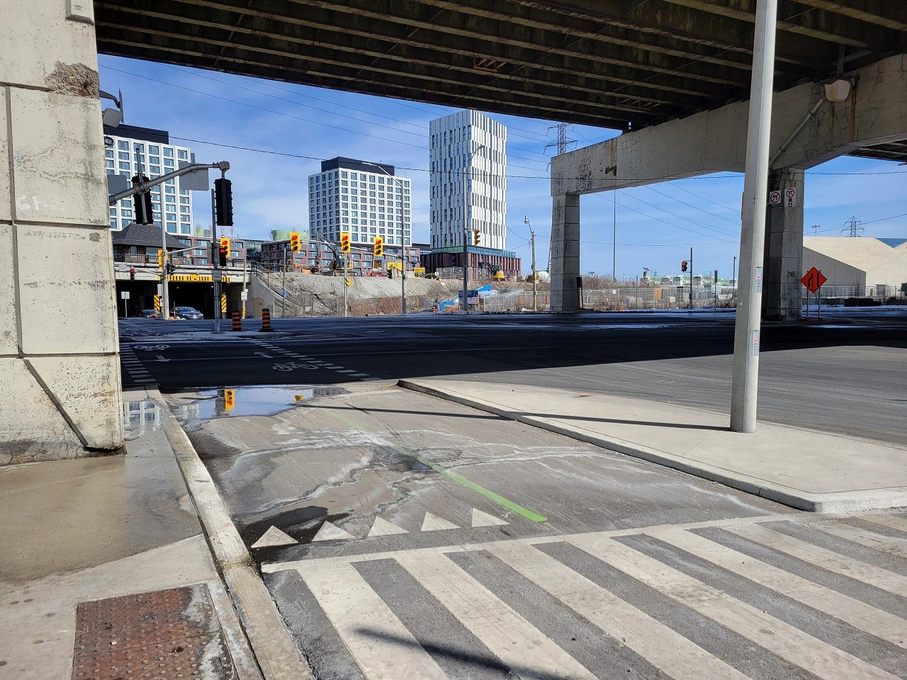
Stop 2: The Cherry Street North Bridge

This pair of bridges cross the Keating Channel, the only existing outlet for the Don River into Lake Ontario after the original river mouth at Ashbridge’s Bay Marsh was filled in.
The smaller bridge to the east, without a road leading up to it, is a future dedicated transit bridge. Eventually, a streetcar will use that bridge to continue into the Port Lands. In the meantime, it will be planted as a meadow with access for people. Learn more about the Waterfront East Light Rail Transit project.
These bridges are part of a family of bridges at three locations all sharing a similar form. The arches are unique in that they are curved in two directions. A limited number of firms can do those kinds of bends, so that component was built in the Netherlands. Then they were assembled in Dartmouth, Nova Scotia, before being shipped along the St. Lawrence Seaway to Toronto!
Continue south.
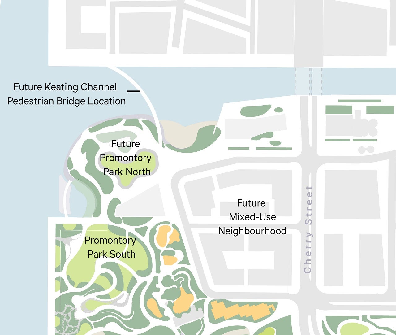
Stop 3: Promontory Park North
As you go south, the large open area to the west is a combination of future parks and a small block of future mixed-use community. The flat grassy area will become Promontory Park North, which is not being delivered as part of PLFP. The area further south, undergoing construction, is future Promontory Park South, which will be open in 2025.
This area will become Promontory Park North as part of future development on Villiers Island.
Promontory Park north is where the new Keating Channel Pedestrian Bridge will connect Villiers Island to Quayside.
When you reach Commissioners Street, turn left to go east.
Stop 4: Commissioners Street
As you walk down Commissioners Street, there are a few things to point out.
-
The sidewalk is currently only on the north side of the street. That is because we are still using the space set aside for the future transit right-of-way for construction vehicles. In 2025, there will be a sidewalk on the south side of Commissioners Street, next to the future transit right-of-way.
-
South of Commissioners Street, you can see another park under construction, also opening in 2025. This park will feature unusual play areas like a playscape inspired by the Cheltenham Badlands, a pebble beach and picnic area near the river.
-
The area north of Commissioners is where future development is planned for the community that will be lined by the new river and parks. The vision for this community was set out in the Villiers Island Precinct Plan, approved by Toronto City Council in 2017, and is being updated to increase the amount of housing that can be built here, including affordable housing . Public Information Centres - Waterfront Toronto (portlandsto.ca)
Keep going east until you see a red brick building on your right.

Stop 5: The Firehall
About halfway along Commissioners Street, you will see a brick building on the south side. This is the historic Firehall 30, which served as the fire station for the Port Lands until 1980.
-
This building will be preserved and renovated to include public bathrooms and space for the City of Toronto’s Parks, Forestry, and Recreation department.
-
The Firehall was moved 20 metres from its original foundation to make room for the transit right-of-way along Commissioners Street. Learn more about how we moved the Firehall: How to Move a 1920s Fire Hall | Waterfront Toronto (waterfrontoronto.ca)
Keep going east until you reach the Commissioners Street bridge.
Stop 6: Commissioners Street Bridge
This bridge is the longest one we built in the Port Lands: it arrived in two halves! The bridge’s sidewalk is designed with space for people to stop and take in the views, so walk along it until you reach about halfway.

The sidewalk on the Commissioners Street bridge has a little bump-out halfway along it, to give people space to stop and take in the views.
Look south:
-
If you’re on a bike using the bike lane, you will already be on the south side of the bridge.
-
If you’re walking, you will be on the north side of the bridge. You can still see a lot by looking through the bridge’s arches. Eventually a second bridge will be installed beside this one, dedicated to transit. That bridge will have a sidewalk on the south side.
-
You can see the new path for the Don River. The river curves towards the west in a way that mimics the way a natural river meanders.
-
Looking directly south, you might be able to see the Don Greenway. It has some tall dead trees installed to provide chimney swift habitat, and an osprey platform.
Look north: (if you’re cycling, you will want to go to the end of the bridge and turn around to come back west on the north side bike lane).

Looking north, you can see the new river, as well as a wetland protected by a carp gate. You can also see future recreational trails.
-
You can see the river full of water! The large boulders that line the river channel create what we call the ‘Ice Management Area’. The rocks catch and break up ice that might come down the river before it can get to the softer, more natural river materials downstream.
-
To the left, you can see a wetland that is mostly separated from the main river channel. The concrete structure you see is a carp gate – it is designed to keep invasive fish out of the wetland.
-
The path you see between the river and the wetland is part of the future recreational trails. In total, we’re building over 6km of new trails to explore!
-
The wetland is an important part of the design for flood protection. In a major storm, the water in the main river would get high enough to flow over the top of the riverbank where you see the trail. Then, the wetlands serve as overflow capacity for the floodwaters.
-
At the far end of the river, you will see a concrete wall. This is the only remaining visible portion of an underground wall that actually runs around the entire river valley. The part you see is the section that we will eventually remove to connect the Don River with the new river valley. This section has been dubbed the ‘north plug’, but it is not a plug like you would have in a bathtub. When it is time to remove it, it will be carefully cut into pieces and pulled out of the water in large chunks.
-
The concrete walls around the full river valley were used to keep groundwater out of the new river valley while we excavated it. That’s because it is a lot easier to dig out dry soil than soil that is full of water. Because the Port Lands are so close to the lake, the water table is very high – without the cutoff walls, water would pool into any holes we dug. The walls also keep the edges of the excavation from collapsing inwards.
Head back east to new Cherry Street, turn left to go south on Cherry Street.
Stop 7: Promontory Park South
As you go south on Cherry Street, you will see construction happening to your right. This area will become Promontory Park South. It will feature a lookout point over the inner harbour and a Water’s Edge Promenade on the western edge. You can also see the future location of PlayPark. Planned as a unique experience for all ages, with play features unlike anything in Canada, this 3 acre (1.21 hectare) destination is not yet funded.
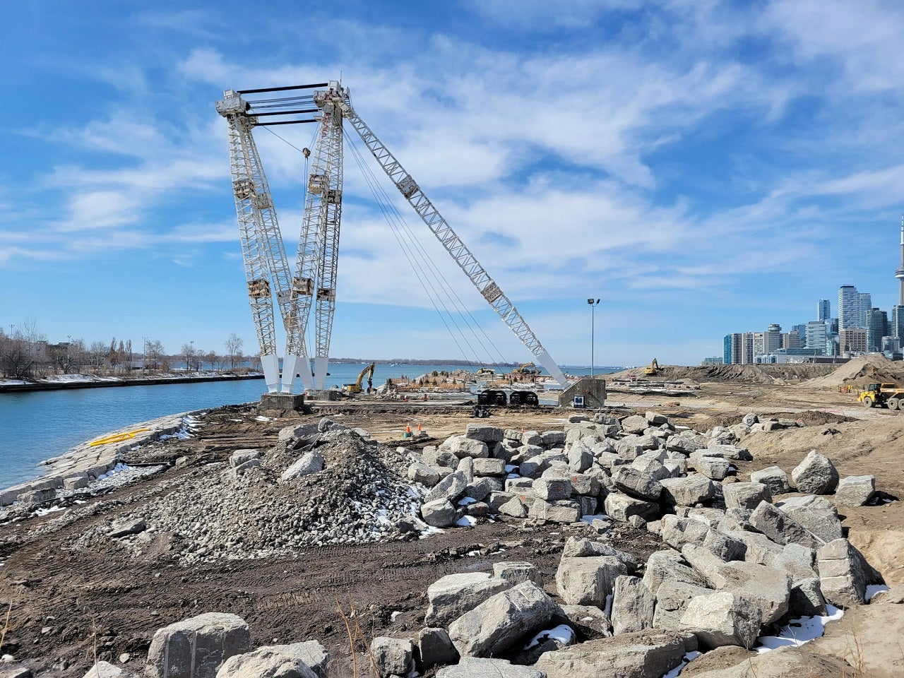
The Atlas Crane will become a new landmark in the parks.
Continue south to the yellow bridge.
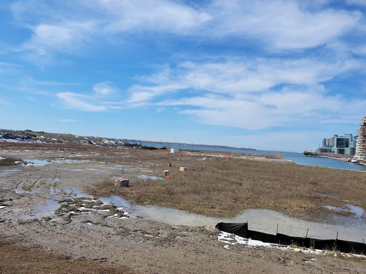
Stop 8: Cherry Street South Bridge
This bridge was the first to open, in the fall of 2022. Looking west, you’re looking over the new mouth for the Don River – where the river will soon spill out into the lake.
-
The large white structure you see is the Atlas Crane – the last of its kind on the Great Lakes and a designated heritage structure. It has been reinforced to ensure its stability. We also gave it some ‘socks’ to deter people from trying to climb it.
-
The north side of this channel used to look a lot like the south side: a hard and straight dockwall. We’ve excavated a more natural and organic shoreline. Beyond the Atlas Crane you can see a cluster of small islands. These are offshore from a pebble beach which was designed as a place to launch small boats like kayaks and canoes. While canoe cove and the new river look almost done, a lot of construction is still happening here.
Have any questions about what we’re building? Rocky @TheRockRipper is on Twitter and Instagram to answer them!