Yonge Slip Design Refined to Enable Eastern Waterfront Transit
PUBLISHED: DECEMBER 6, 2024
In This Blog:
-
In November 2023, the City of Toronto approved funding to advance above-ground components of the Waterfront East LRT project to detailed design. Yonge Slip was identified as one of two “Early Works” components to prioritize.
-
Waterfront Toronto is working in partnership with the City of Toronto and the TTC to redesign the head of Yonge Slip to accommodate future LRT service, while improving the experience and efficiency of travel for users in the area.
-
We incorporated feedback from stakeholders, design experts and the public to refine the design concept in a manner that ensures the future slip will provide space and navigational clarity for all users, while accommodating the future LRT.
-
On November 27, the project team presented to the Waterfront Design Review Panel for feedback that will be incorporated to refine the 60% detailed design.
In November 2023, the City of Toronto approved funding to advance detailed design for above-ground components of the Waterfront East LRT (WELRT) project. The City identified two “Early Works” which are critical pieces of the project that need to be completed in order to enable the future LRT construction. Yonge Slip was identified as one of two “Early Works” components to prioritize (the other being the Queens Quay East extension to Cherry Street, which went to the Waterfront Design Review Panel (DRP) in October 2024. Redesigning Yonge Slip is required as a first step to enable construction of the LRT portal that will connect the underground components of the line with the above-ground section on Queens Quay at the head of the Slip. Waterfront Toronto is working in partnership with the City of Toronto and the TTC to redesign the head of Yonge Slip to accommodate future LRT service, while also improving the experience and efficiency of travel for users in the area.
Yonge Slip, located at the foot of Yonge Street and serving as a marine hub along the waterfront, is a bustling space along Queens Quay with a wide variety of users. Based on extensive study of the space, we have noted key challenges that will need to be addressed in the design, including:
- Accommodating the future LRT portal to the northwest of the Slip (as part of broader WELRT project), access to properties south of Queens Quay directly adjacent to Yonge Slip will need to be reconfigured to be provided from the east.
- Overlapping movements between pedestrians, cyclists and vehicles along Queens Quay adjacent to the Slip can pose potential conflicts and would be improved by clearer delineation, signalization of vehicular movements south of Queens Quay, and clarity of access paths for all users.
- The Yonge Slip is an important hub for marine uses, including the City of Toronto Ferries, water taxis, and other chartered and private marine services. This is a unique feature of Toronto’s waterfront, and the design is intended to facilitate continued marine activity in this location.
What feedback have we heard on the design of the Slip?
Waterfront Toronto and our project partners at the City of Toronto and TTC have consulted with stakeholders, Indigenous communities, and members of the public regarding the WELRT project. This engagement was held through public meetings and events, stakeholder meetings, a public survey, and the Transit and Rail Project Assessment Process. Through this engagement, we heard the following feedback regarding Yonge Slip:
-
A desire to reduce (or eliminate if possible) the volume of lakefill, in order to minimize impacts to aquatic habitat in the slip and preserve the area’s connection with Lake Ontario.
-
The importance of the Yonge Slip as a marine use hub, and a need to preserve future marine transportation uses following completion of the project.
-
Needed improvements to separate different users in the area, including pedestrians, cyclists, personal vehicle traffic, motor coach pickup and drop-off, and heavy vehicle loading activities.
The project team has used this feedback to guide the refined Yonge Slip design and have set the following objectives:
-
Minimize slip infill and impacts to marine transportation uses and aquatic habitat.
-
Improve separation of users on the slip and facilitate clearer paths of travel.
-
Build a continuous public space amenity that accommodates all users and enhances the area’s connection with Lake Ontario.
-
Improve Yonge Slip’s marine hub programming, noting the importance of this site as a major marine and transit hub that is essential for easing pressure on the ferry system.
Where is the design going?
On November 27, the schematic plans for the refined Yonge Slip design were presented to the Waterfront Design Review Panel (DRP) as a part of the WELRT project. The purpose of the DRP review at this stage is to evaluate the schematic design for this portion of the WELRT and give the design team feedback on how it is integrated with the public realm.

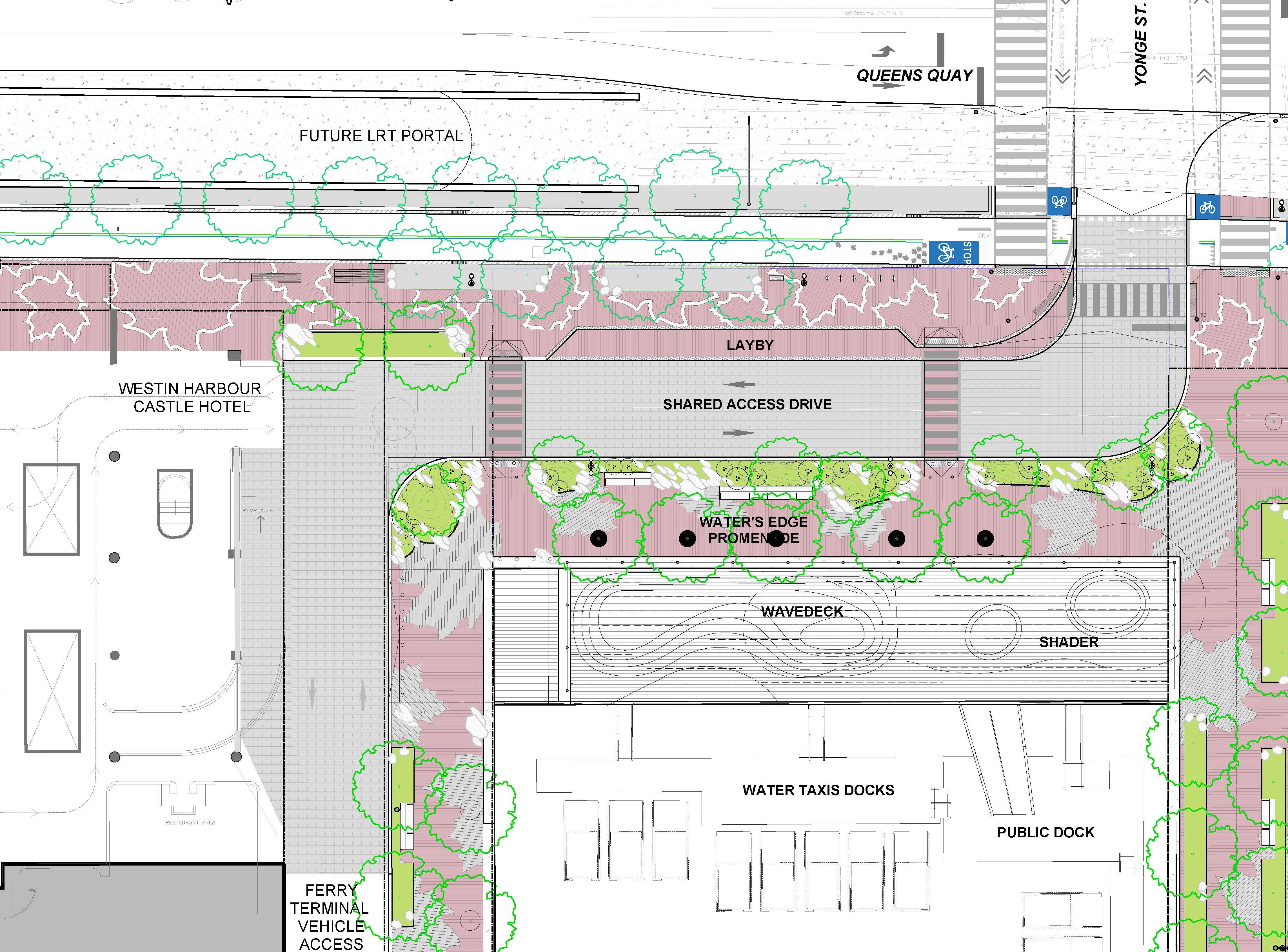
Layout of refined Yonge Slip design showing the various components of the slip.
The updated design has integrated the objectives identified through consultations by creating:
-
A signalized intersection at Yonge Street, enabling clear vehicle movements across the Martin Goodman Trail and south side promenade.
-
Clear paths for vehicles to access the Ferry Terminal and Westin Harbour Castle hotel.
-
Space for loading and servicing vehicles serving the south side of Queens Quay to navigate while avoiding conflicts with pedestrian and cyclist thoroughfares.
-
A landmark public space at the foot of Yonge Street and along the Queens Quay corridor, inviting people onto the waterfront and enhancing the area’s connection with Lake Ontario.
Diagram of potential routes taken to access the slip for various users.
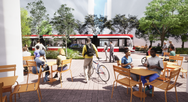
The updated design of Yonge Slip not only improves clarity and wayfinding, but it also re-connects Queens Quay to the water and closely integrates the public space with the marine activity co-existing beside it.
Rendering of refined Yonge Slip design presented to the Design Review Panel.
What are the next steps?
We plan to complete the detailed design of Yonge Slip in 2025 as part of the WELRT project. Feedback received from the Design Review Panel and stakeholders will be applied as the design advances.
Sign up for our newsletter to stay up to date on our projects.


