Public Art Plan Envisions a Free, Outdoor Museum in the Port Lands

Photo Credit: Waterfront Toronto / Norm Li
PUBLISHED: JULY 26, 2024
In this blog:
- In June, Toronto City Council formally adopted the Villiers Island and Keating West Public Art Master Plan.
- The plan builds on the success of Waterfront Toronto’s West Don Lands and East Bayfront public art master plans.
- It sets the stage for the commissioning and creation of 15 permanent pieces across the two precincts, along with the Lassonde Art Trail, a free outdoor museum that follows the undulating curves of the new mouth of the Don River.
- The master plan was created in consultation with local communities and subject matter experts in public art, city-building, Indigenous storytelling, and community practice.
- The works will explore water and the waterways that define these areas and their relationship to the landscape, uncovering the co-existing layers of histories and cultures.
- The way this plan comes to being is key to its success, including a commitment to increasing Indigenous presence on the waterfront and promoting diversity and inclusion.
Enhancing the cultural vibrancy of the waterfront is at the heart of Waterfront Toronto’s mission. Through our public art master plans we embed public art into the everyday life of our new neighbourhoods, creating a sense of place and contributing to lively, inspiring communities.
In June, Toronto City Council formally adopted the Villiers Island and Keating West Public Art Master Plan. This plan builds on the success of Waterfront Toronto’s West Don Lands and East Bayfront public art master plans, which have resulted in the creation of memorable artworks such as Water Guardians in the West Don Lands and Light Showers in East Bayfront.
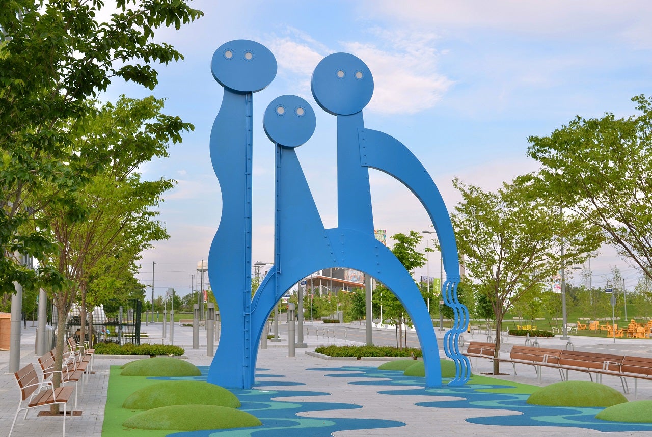
Water Guardians by Jennifer Marman and Daniel Borins has become a beloved part of the West Don Lands neighbourhood.
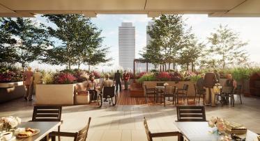
The Villiers Island and Keating West Public Art Master Plan sets the stage for the commissioning and creation of 15 permanent pieces across the two precincts. It includes plans for a free outdoor museum that follows the undulating curves of the new mouth of the Don River, which in 2022 was supported by a visionary $25 million donation from the Pierre Lassonde Family Foundation. Called the Lassonde Art Trail, this innovative trail will include three permanent works and 15 locations for temporary works that will be programmed throughout the year. It will create a national attraction – helping to bring hundreds of thousands of local, regional, and international visitors to the waterfront every year.
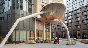
The master plan calls for public art to be sited in prominent locations, connecting waterways to promenades and bridges, parks and plazas. This will range from high-impact pieces, like the recently announced Unfinished Arch, to more subtle, discoverable artworks, similar to Lisa Hirmer’s work for the 2022 waterfront art-in-residence program, which are both located in the nearby East Bayfront area. An important aspect of this plan is its commitment to increasing Indigenous cultural presence on the waterfront, building on the ways that designs for the parks and river showcase Indigenous histories, resilience, and interconnectedness to the natural environment.
This master plan calls proposes temporary artworks like Lisa Hirmer’s Infrastructures for a Reimagined Landscape, produced as part of the 2022 Waterfront Artist in Residence Program.
How was the public art master plan created?
The plan responds to planning and development documents, including the Official Plan and the Waterfront Secondary Plan, and was built in concert with the Villiers Island and Keating West Precinct Plans, so that art becomes embedded in the vision for the area’s public realm design. It proposes art that responds to its surroundings, including the new mouth of the Don River, the Keating Channel, and the Gardiner Expressway.
The master plan was created by Waterfront Toronto creative consultants, Bespoke Cultural Collective, in close consultation with the City of Toronto and local communities and subject matter experts in public art, city-building, Indigenous storytelling, and community practice, including The Bentway, the West Don Lands Committee, Oddside Arts, and Monument Lab.
Together, the collaborators developed guiding principles that are the backbone of this plan:
- Explore layered histories
- Honour Indigenous peoples and histories
- Respect the environment
- Engage with contemporary issues
- Promote diversity and inclusion
- Variety of artwork
- Artistic excellence
This engagement process also uncovered a natural unifying theme: water. These two precincts sit close to important bodies of water. The Don River and Lake Ontario are central to these areas, while smaller bodies of water like the Keating Channel, Parliament Slip, Polson Slip, the Ship Channel and the inner harbour form part of a connected system, both natural and human-made, that characterize the landscape.
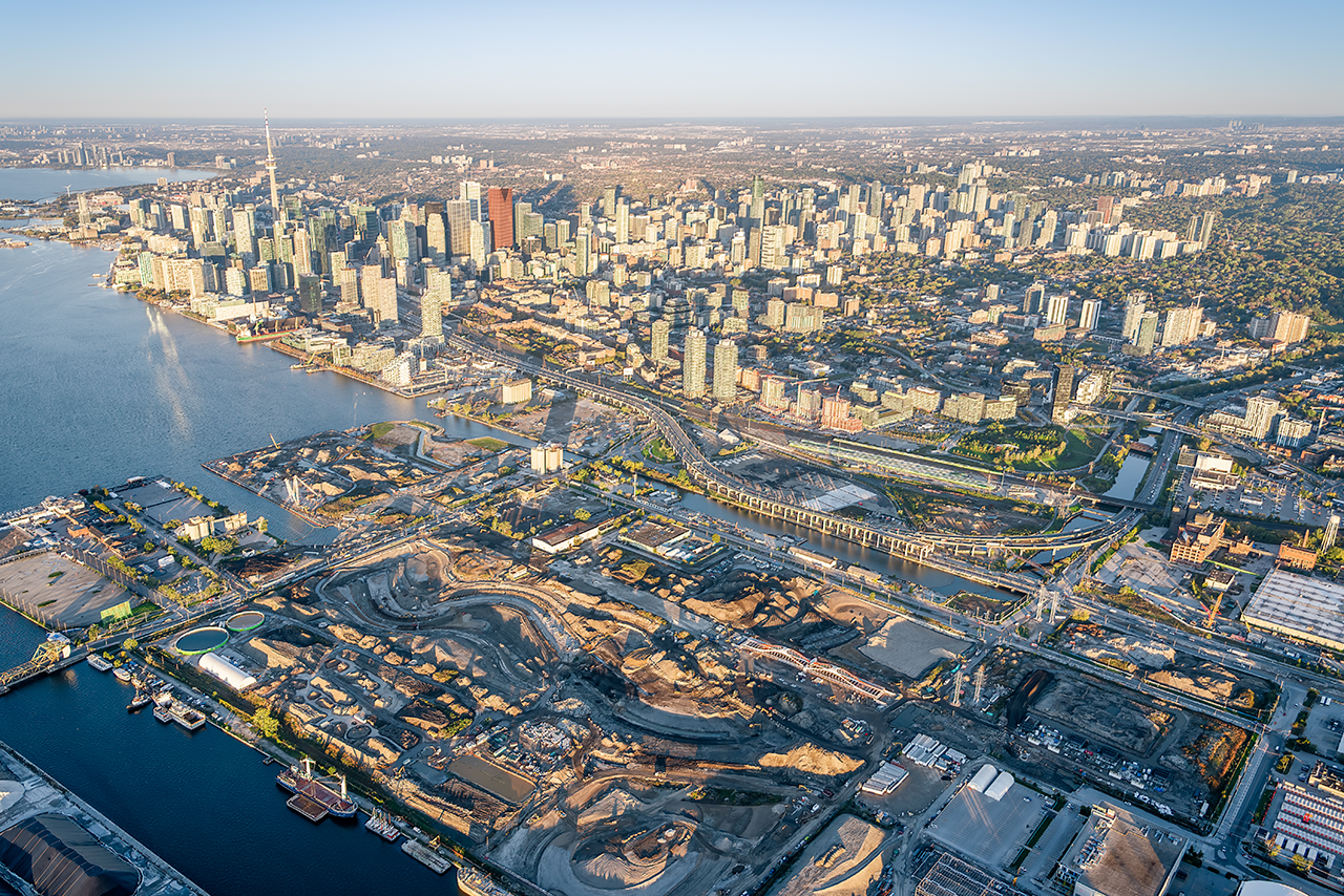
This aerial shot of the eastern downtown waterfront shows the location of these two precincts in context with adjacent waterways and infrastructure. Since this photo was taken, an extension of the Don River has been nearly completed, creating the island temporarily called “Villiers Island.”
Water is central. Therefore, the works will explore the ways water and waterways define these areas. The artworks will explore these themes:
- Waterways
- Public Art of Our Time
- Multiple and Layered Histories
- Commitment to the Environment
- Indigenous Place-Knowing
How will the works come to be?
Implementation is not a second thought. The way this plan comes to being will be the key to its success, including a commitment to increasing Indigenous presence on the waterfront and promoting diversity and inclusion. Waterfront Toronto’s public art team will work with City of Toronto staff, artists, fabricators and installers to make this vision come to life.
Commissioning art works of differing scales through open calls will provide opportunities for local, national and international artists at different stages in their career. Selection committees will be composed of peers and will represent Toronto’s diverse communities and will include technical advisors for more complex projects. Interpretation will be accessible and inclusive. Maintenance will be included in the budget for each piece.
Like other public art in Toronto, these new works will be funded through the Percent for Public Art Program, which directs a portion of the Community Benefits Contributions paid to the City by developers as part of the development approvals process towards the creation of public art. Individual permanent pieces are funded by pooling developer contributions from across each waterfront district, building on the City of Toronto’s Percent for Public Art model. Once complete, each artwork becomes part of the City of Toronto’s Public Art and Monuments Collection. A portion of this budget will be reserved for long-term maintenance by the City of Toronto. The temporary works in the Lassonde Art Trail will be managed by the Lassonde Art Trail Foundation, a new non-profit, and funded through philanthropy.
This cohesive and unifying vision for public art will enrich these two communities — creating moments of inspiration, beauty and joy for thousands of new residents and estimated millions of visitors to Villiers Island and Keating West. We can’t wait to get started commissioning and installing inspiring public art across the new island and Keating West.
Stay up to date on the exciting work that is happening along Toronto’s waterfront by subscribing to our newsletter.